World's Oldest Map
This tablet has been dated to the Early Bronze Age (specifically EBIV for those familiar with the dating vernacular).
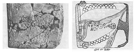
In layman's terms, that's between 2300 and 2000 BC. This is the earliest period usually ascribed to Abraham by those who believe he was a historic figure. Interestingly enough, the map names Ebla--a city with one of the ancient libraries of cuneiform texts that richly expanded our historical knowledge when we unearthed it.
An interesting thing about this map is that it's direction does not follow our Modern day conventional maps. Up is not north, it's east. Down is not south, it's west. The map shows four rivers which begin in the north (left) and flow across the land, between mountain ranges, to meet in the south-east (upper-right). Can you guess which rivers and region this happens to be?
posted by slaveofone at 12:00 AM
![]()
1 Comments:
One place immediately comes to my mind, a place shrouded in mystery and controversy.
The Bible describes this area using four rivers originating from the fabled Garden of Eden: Pishon, Gihon, Tigris, and Euphrates.
The Tigris and Euphrates are located in modern day Iraq.
Post a Comment
<< Home